On the Water with Garmin
Singapore/ May 5, 2011 - Garmin Corporation, a unit of Garmin Ltd., the global leader in satellite navigation, proudly unveil a brand new stand featuring the best selection of marine products at Boat Asia, 12th to 15th May, Marina at Keppel Bay, Singapore. Check out the 15” colour touchscreen chartplotters; the latest GHP™ 12 Autopilot for Sailboat, the integrated VHF communications; or the growing array of NMEA 2000 instruments; plus the Asian dedicated standalone chartplotter, the new line of Garmin echo series fishfinders as well as the rugged handhelds. They are easy to use! Look no further for all your marine electronics requirements than Garmin, the marine experts
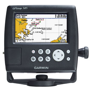
Asian dedicated standalone chartplotter
 GPSMAP® 585 series by adding a high sensitivity GPS receiver for faster satellite acquisition and an improved digital design for increased map drawing and panning speeds. Building upon the success of the GPSMAP® series and Garmin’s proven easy-to-use interface, the new Asian dedicated chartplotters in the GPSMAP® 585 and 580 come standard with an internal high-sensitivity GPS receiver that allows for faster acquisition times and superior satellite tracking so that boaters are able to acquire and maintain a GPS fix more easily. In addition, these units boast an improved, high-speed digital design that will increase map drawing and panning speeds, making chart adjustments extremely fast.
Ultra-sharp and easy-to-read, the GPSMAP® 585 series with its brilliant 5-inch WQVGA colour display makes no excuses. GPSMAP® 580 and 585 are preloaded worldwide basemap. With a SD card slot, it’s easy to add additional maps without connecting to a computer. Furthermore, the 585 series, Garmin Asian dedicated chartplotters, not only support English but also support unique Asian languages including Simplified Chinese and Bahasa Indonesia.
Where applicable, the sounder version, GPSMAP® 585, comes with optional transducer that can clearly illustrate depth contours, fish targets and structures. In addition, this powerful sounder can scan fish, structure or other objects as deep as 1,500 feet. Whether you’re fishing in freshwater or off the coast, you can always find right Garmin transducers of various kinds to suit your needs. The GPSMAP® 580 and 585 are also NMEA 0183 compliant for connectivity with sensors, instruments and future marine offerings. GPSMAP® 585 is designed specifically for professional fishermen. What’s more, you can now fish with a high quality combo chartplotter at more affordable cost.
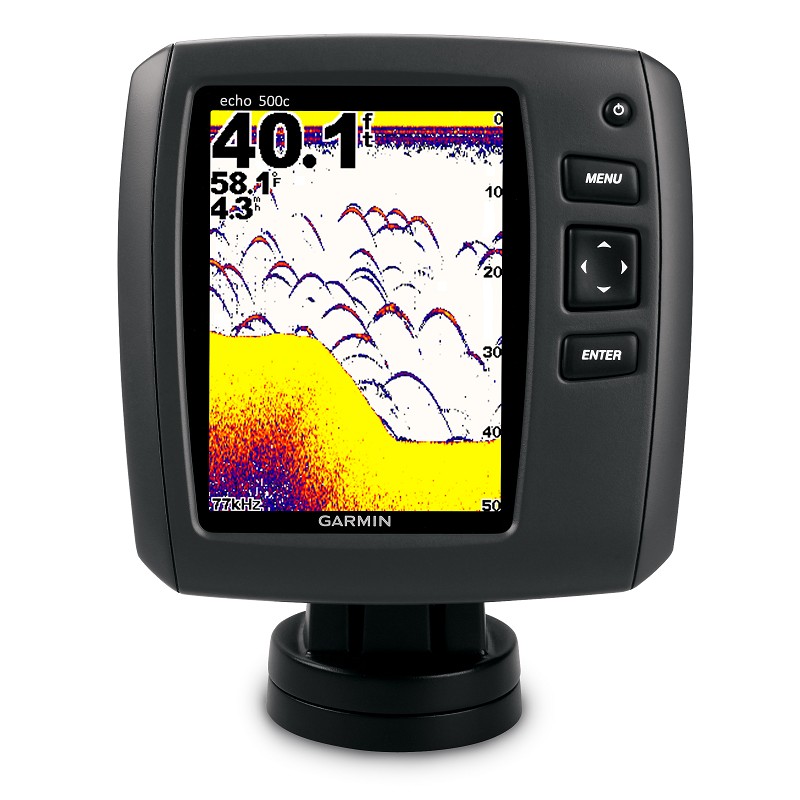
echo series fishfinders
A new line of standalone fishfinders raise the standard for freshwater sonar performance and ease of use. From economical 8-level grayscale units to a full array of super-bright colour models, these new Garmin systems sport an updated look, and with Garmin HD-ID™ target tracking technology, they deliver the separation and definition fisherman need and expect.
 The premier high resolution echo 550C features an ultra-sharp video-quality 640x480 pixel 5-inch VGA screen, a powerful 500-watt sonar transmitter, and offers excellent fish arch display and bottom tracking as deep as 1,900 feet. The echo 550c is dual beam (200/77 kHz) capable and gives optimum deep or shallow water performance with up to 120 degrees of effective fish scanning area. Garmin’s echo 500C boasts the same aforementioned premium features, and offers a crisp 256-color QVGA display which gives 320x234-pixel resolution for extra-sharp detail on fish returns, structure and bottom soundings.
For the fisherman on a budget, the echo 300c is a great color sonar option and uses Garmin’s exclusive HD-ID target tracking technology to give you a crystal-clear picture of fish returns and bottom features on its 3.5-inch TFT display. The echo 300c is the first in its class to offer dual-frequency compatibility that lets you optimize performance for deep or shallow water. The 300-watt RMS sounder can scan as deep as 1,500 feet with up to 120 degrees of viewing angle to see targets fish well beyond the sides of your boat.
These new systems come with everything you need – including a trolling motor transducer mount – to make getting on the water even faster and easier. All new models also come standard with a quick-release mount with tilt and swivel included, and the 5-inch units also include a quick-disconnect cable management system. An optional flush-mount kit is also available for each model.
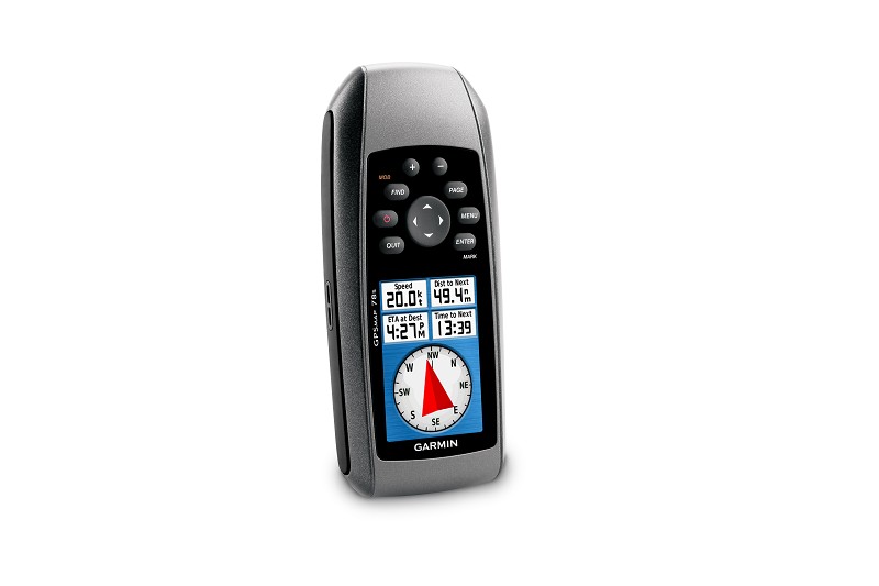
Marine GPS handhelds
 GPSMAP 78s, the newest of Garmin’s next generation marine-friendly GPS handheld feature a new contemporary industrial design with rubber side grips that’s ideal for navigating the great outdoors. Furthermore, it supports Thai and Bahasa Indonesia, which makes it much more user-friendly in Asia.
Thanks to the bright, highly transflective 65K color LCD display with backlight, GPSMAP 78s is easier than ever to read and use in all conditions. Like earlier GPSMAP generations, these new handhelds will keep the same soft-key user interface and overall sleek, easy-to-use design – including in a rugged and waterproof housing that floats. Other key upgrades to the GPSMAP 78s includes user-defined profiles and a 3-axis tilt-compensated electronic compass, which shows your heading even when you’re standing still. The new GPSMAP 78s also support wireless exchange of tracks, waypoints, routes and geocaches with compatible Oregon®, Dakota®, Colorado® and Foretrex® devices.
Weighing 7.7 ounces, the new GPSMAP 78s lasts up to 20 hours on two AA batteries. Each device has a high-sensitivity GPS receiver with HotFixTM, which automatically calculates and stores critical satellite information and can use that information to quickly calculate a position. The new GPSMAP 78s has 1.7 GB of internal memory and a microSDTM card slot for optional map data, so users have the ability to add additional BlueChart® g2 marine charts, topographic maps or CityNavigator® data for turn-by-turn routing on roads. With these units, you can store up to 2,000 waypoints, 200 routes and a tracklog of up to 10,000 points and 200 saved tracks.
For more information, including availability, visit www.garmin.com.sg/products/onthewater/
About Garmin Corporation
Garmin Corporation, is a unit of Garmin Ltd. (Nasdaq: GRMN), the global leader in satellite navigation. Since 1989, this group of companies has designed, manufactured, marketed and sold navigation, communication and information devices and applications – most of which are enabled by GPS technology. Garmin’s products serve automotive, mobile, wireless, outdoor recreation, marine, aviation, and OEM applications. Garmin Ltd. is incorporated in Switzerland, and its principal subsidiaries are located in the United States, Taiwan and the United Kingdom. Garmin, Bluechart, City Navigator, Colorado, Foretrex and Oregon are registered trademarks and Dakota, is a trademark of Garmin Ltd. or its subsidiaries.
Notice on forward-looking statements:
This release includes forward-looking statements regarding Garmin Ltd. and its business. All statements regarding the company’s future product introductions are forward-looking statements. Such statements are based on management's current expectations. The forward-looking events and circumstances discussed in this release may not occur and actual results could differ materially as a result of known and unknown risk factors and uncertainties affecting Garmin, including, but not limited to, the risk factors listed in the Annual Report on Form 10-K for the year ended December 27, 2008, filed by Garmin with the Securities and Exchange Commission (Commission file number 0-31983). A copy of Garmin’s Form 10-K can be downloaded at www.garmin.com/aboutGarmin/invRelations/finReports.html. No forward-looking statement can be guaranteed. Forward-looking statements speak only as of the date on which they are made and Garmin undertakes no obligation to publicly update or revise any forward-looking statement, whether as a result of new information, future events, or otherwise.